Quick verdict
GEO4X is worth considering if your real problem is not “I need another cloud drive,” but “I need a safer way for clients, field teams, and technical users to view the same geospatial project without passing huge files around.”
That is the buying tension here.
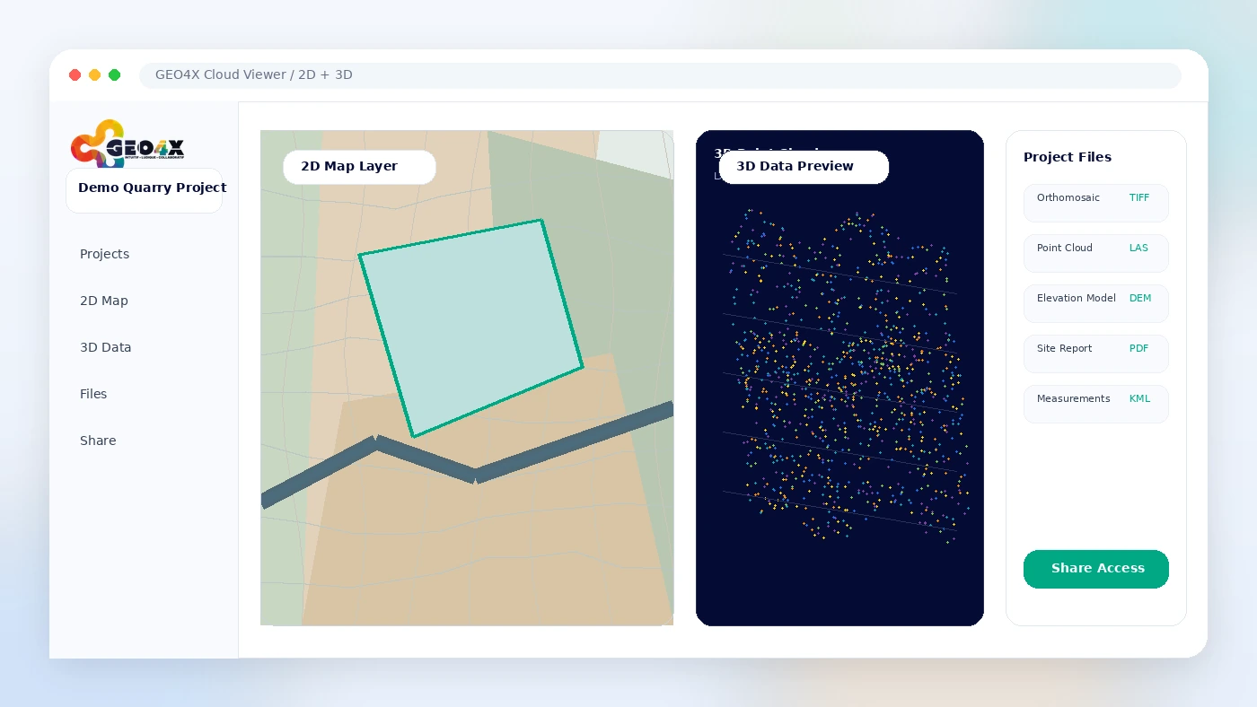
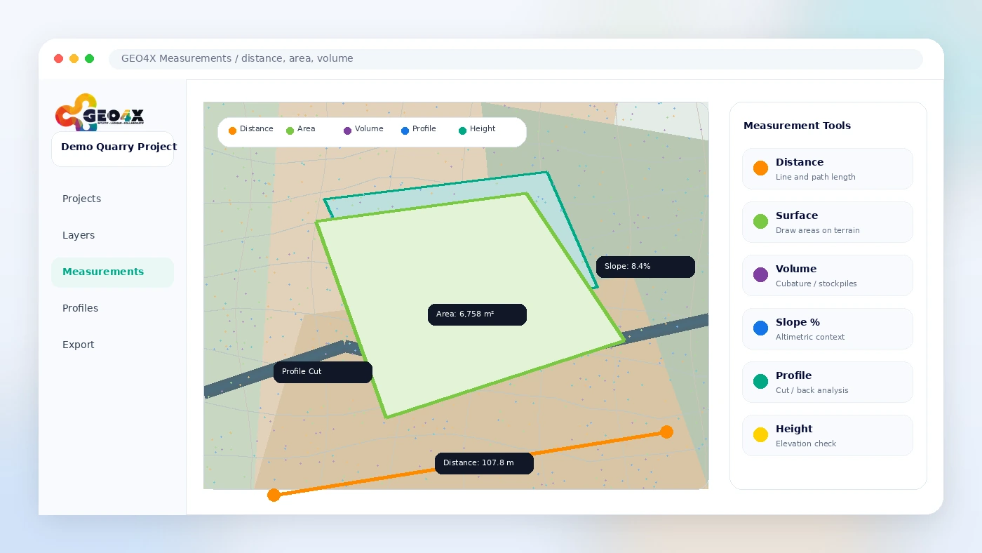
The product looks simple on the surface: upload 2D and 3D georeferenced data, view it in the browser, take measurements, share access, and keep project information in one workspace. The more useful question is narrower: does that browser-based handoff solve a repeated problem in your drone mapping, construction, inspection, stockpile, infrastructure, or survey workflow?
For my money, GEO4X makes the most sense for teams that already produce or receive geospatial deliverables and need a collaboration layer around them. It is not the first tool I would choose if the buyer mainly needs a full photogrammetry production engine, a desktop GIS replacement, or a basic file-sharing folder. It becomes stronger when stakeholders need to open a project, inspect a point cloud or orthomosaic, measure something, download supporting files, and understand the site without specialist software.
The main strength is workflow clarity. The main caution is plan fit. Storage, permanent users, temporary users, data retention, Pro trial timing, tax, and client access matter more than the headline monthly price. The safest next step is to test a demo or Freemium workspace with a real dataset before checking paid pricing or any offer route.
Next step: If GEO4X looks relevant to your project handoff workflow, test the current buyer route before treating the Pro plan as the obvious answer.
Review snapshot
| Review point | Practical take |
|---|---|
| Best for | Drone mapping, survey, construction, inspection, quarry, infrastructure, and geospatial service teams |
| Not ideal for | Buyers who only need basic file storage or a full desktop photogrammetry production suite |
| Main use case | Browser-based viewing, measuring, sharing, and organizing 2D/3D georeferenced project data |
| Pricing note | Freemium is available; Pro is publicly shown at €54.99/month excl. tax, with annual savings shown on the pricing page |
| Trial path | Pro trial is presented as 15 days with no credit card required |
| Main strength | Turns heavy geospatial deliverables into a shared project workspace for collaborators and clients |
| Main concern | Paid value depends on storage, users, dataset type, cancellation timing, and whether the hosted viewer replaces a real workflow pain |
| Direct alternatives | Pix4D, DroneDeploy, WebODM, Propeller Aero |
| Best next step | Open demos or Freemium first, then test Pro with a real client-style project |
What is GEO4X?
GEO4X is best understood as a cloud geospatial collaboration platform for teams that work with 2D and 3D georeferenced project data.
In plain English, it gives buyers a browser-based place to visualize, measure, host, share, and manage access to geospatial deliverables. The official positioning centers on projects such as orthomosaics, digital elevation models, point clouds, thermomaps, site inspections, volume measurements, terrain data, infrastructure monitoring, and client collaboration.
That matters because GEO4X is not just another productivity SaaS tool. It belongs closer to drone mapping, photogrammetry delivery, site monitoring, and geospatial project review. A buyer evaluating it like a generic business platform will probably miss the real question.
The common wrong expectation is to treat GEO4X as either a simple file drive or a complete desktop processing suite. It is more specific than a drive and less broad than a full end-to-end production environment. Its value sits in the middle: making geospatial outputs easier to inspect, measure, organize, and share with stakeholders who may not have the same technical software as the operator.
Our review approach compares public product pages, pricing details, terms, privacy language, buyer workflow fit, and nearby alternatives. We do not treat a discount, free plan, or low-friction trial as proof that the product fits the buyer. For a geospatial platform, the real proof is whether it handles the type of data, users, measurements, and handoff process you expect to repeat.
Who should use GEO4X?
Drone operators who deliver survey or inspection outputs to clients are one of the clearest fits. GEO4X can help when the client needs to see an orthomosaic, point cloud, thermomap, or site model without waiting for a technical operator to export screenshots or walk them through desktop software. The condition is that the browser viewer and permission model must match the way the operator actually delivers projects.
Construction, quarry, and infrastructure teams are another reasonable fit. If a team repeatedly checks stockpile volumes, earthworks progress, roof inspections, facade issues, deformation, terrain, or site documentation, a shared geospatial workspace can reduce the friction of scattered file transfers. Before paying, I would check whether the measurement tools, exports, and storage limits match the scale of the sites involved.
Survey and mapping teams may also find GEO4X useful as a client-facing layer. The value is not only technical. It is communication. A project manager, partner, or visitor can inspect the same hosted data with controlled access instead of asking for new exported views every time a question appears.
Service providers that want branded or white-label project delivery should look more closely at GEO4X. The platform mentions customization and branding, which can matter when geospatial deliverables are part of a professional client experience. That said, customization alone should not drive the purchase. The viewer, access roles, export needs, and data retention rules still matter more.
Who should avoid GEO4X?
I would be careful with GEO4X if you only have one small project and no ongoing collaboration problem. A free demo or Freemium workspace may be enough to understand the idea. A paid subscription is easier to justify when project handoff happens repeatedly.
I would also avoid treating GEO4X as a guaranteed replacement for deep photogrammetry production tools. The platform has a photogrammetry processing path and supports delivered outputs, but a buyer who needs full control over processing pipelines, calibration, quality checks, and production settings should compare it with more production-focused tools before committing.
Teams that need formal survey-grade or legally certified deliverables should slow down. GEO4X can help visualize and measure data, but the terms make clear that deliverables depend on client data quality and are not automatically official surveying or certified topographic documents unless expressly stated. That is not a small detail if your work affects legal boundaries, public works, engineering decisions, or compliance.
A buyer with strict integration requirements should also verify before paying. Public information supports the cloud viewer, access roles, measurements, sharing, demos, and photogrammetry workflow, but API access is not a feature I would assume without direct confirmation.
Finally, avoid buying only because an affiliate or annual savings path appears available. A lower checkout price cannot fix the wrong workflow fit.
How GEO4X fits into a real workflow
A practical GEO4X workflow starts before the upload.
First, the operator or team needs a geospatial project that already has a reason to be shared: a drone survey, roof inspection, stockpile volume check, point cloud, orthomosaic, terrain model, thermographic view, or project document set. Then the buyer tests whether GEO4X can host the relevant files and make them understandable to the people who need to review them.
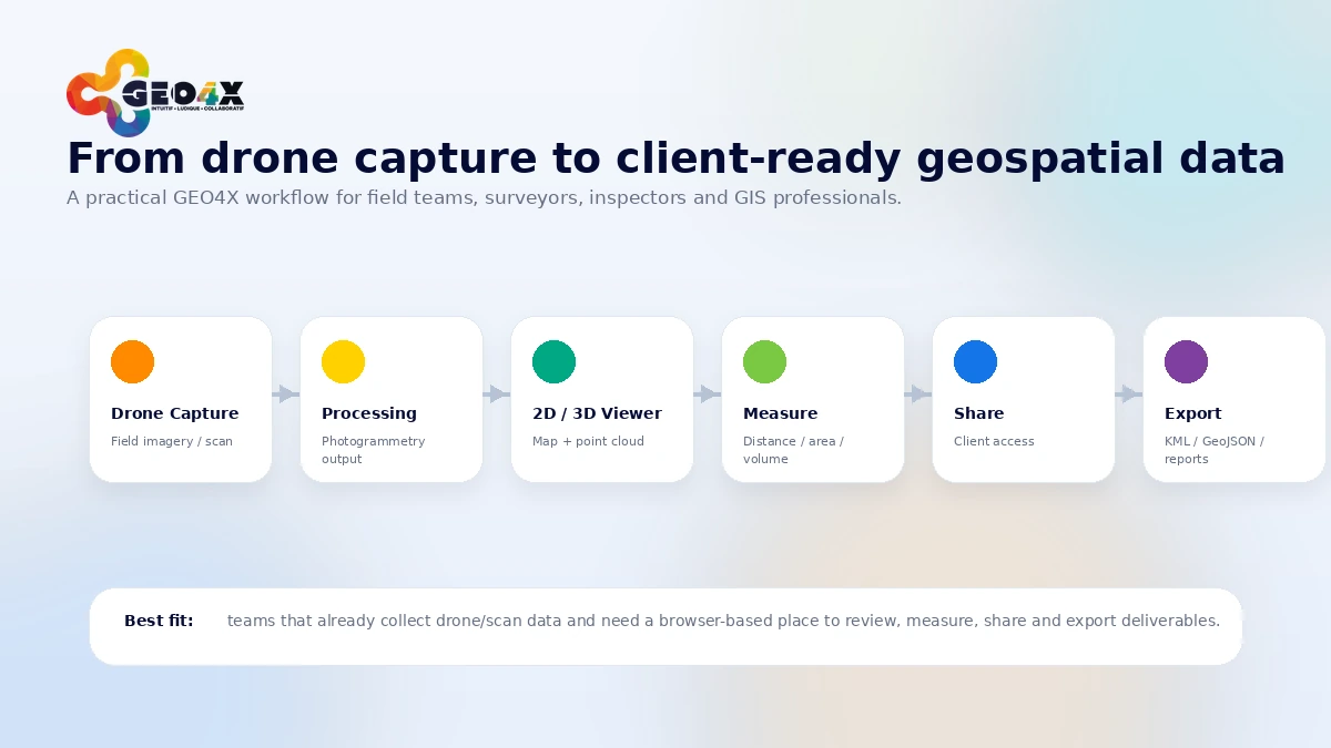
From there, the workflow usually looks like this:
- Prepare or receive the geospatial deliverables.
- Upload the relevant project data into the cloud workspace.
- Use the viewer to inspect the 2D or 3D context.
- Take measurements where needed: distance, area, volume, profile, slope, or related project values.
- Add supporting files or documents.
- Share access with internal users, temporary users, visitors, clients, or partners.
- Let the project stakeholder review, measure, download, or comment based on their role.
- Decide whether the platform reduces back-and-forth enough to justify a paid plan.
That last step matters. GEO4X is useful when it removes a repeated friction point. It is weaker when the buyer uses it once, exports a few views, and never needs a hosted workspace again.
Real-world buyer scenarios
A drone operator delivering survey outputs
A drone operator may use GEO4X after a flight and processing step to package the output for a client. The platform can help if the client needs to inspect an orthomosaic, point cloud, or elevation model without learning specialist software. It may fail if the client simply wants a final PDF report and never opens hosted data.
Before paying, I would test one real client-style project and check whether the client can navigate the workspace without repeated support calls.
A quarry or construction team checking volumes
A quarry, stockpile, or earthworks team may care less about the beauty of the viewer and more about volume checks, measurements, terrain change, and recurring site documentation. GEO4X can fit when teams review data often and share it across operational roles.
The risk is plan mismatch. Storage and user limits matter quickly when datasets are large and stakeholders multiply.
An inspection firm sharing roof, facade, or thermography results
For inspection work, GEO4X can make sense when images, thermal data, 3D context, and measurements need to be organized in a way that non-technical stakeholders can understand. The stronger fit is recurring inspection work with external reviewers.
The buyer should verify whether the platform supports the exact inspection data and reporting format expected by clients.
A geospatial team needing client access control
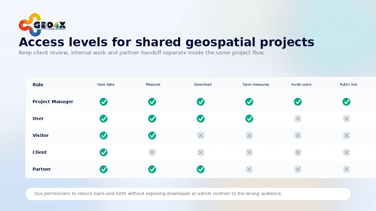
Some teams do not need another processing tool. They need controlled sharing. GEO4X’s access roles can help when project managers, users, visitors, partners, and clients need different permissions.
The buyer check is simple: map your actual access model first. If your team cannot describe who needs to view, measure, download, save, or manage data, it is too early to choose a paid plan.
Key features that actually matter
Browser-based 2D and 3D geospatial viewing
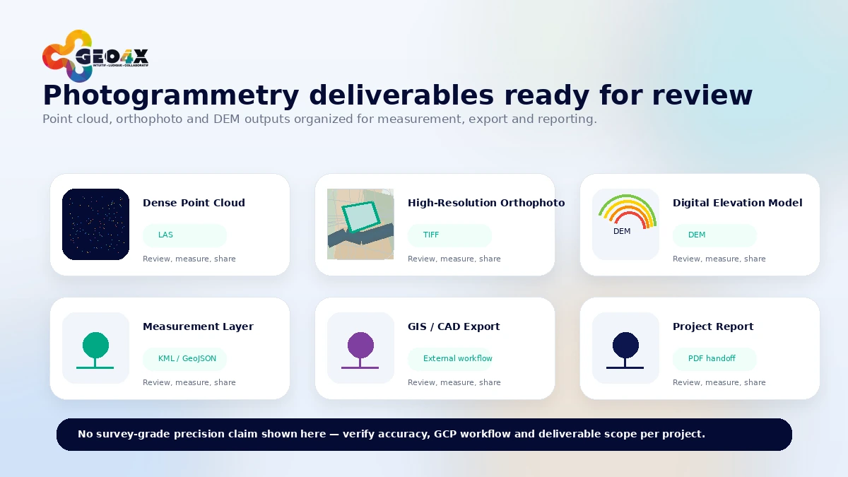
The central feature is not storage by itself. It is browser access to georeferenced project data. GEO4X supports viewing for point clouds, orthomosaics, digital elevation models, thermomaps, and related hosted project files.
Buyer note: this matters most when stakeholders need to open and inspect data without heavy desktop software. It matters less when everyone already works comfortably inside the same professional GIS or photogrammetry suite.
Measurement tools
GEO4X’s measurement layer is a practical reason to care. Distance, area, volume, profile, slope, and related measurements can turn hosted data into a decision tool rather than a passive viewer.
Buyer note: do not assume every measurement is appropriate for every professional or legal use. For engineering, boundary, certified topographic, or regulatory decisions, verify accuracy expectations and contractual scope first.
Sharing and permission roles
Project managers, users, and visitors do not need the same level of access. GEO4X’s role structure is important because geospatial projects often involve internal teams, external clients, contractors, partners, and temporary viewers.
Buyer note: this feature is strongest when you already know your handoff model. If everyone needs the same unrestricted access, the permission system may be less important.
Upload, host, export, and supporting documents
The ability to host geospatial data and supporting documents is useful when a project contains more than one file. Reports, KML files, documents, and hosted data can become part of a shared workspace.
Buyer note: check actual upload types, export needs, and data retrieval rules. A platform that works for demos still needs to work with your file sizes and client expectations.
Photogrammetry processing path
GEO4X also promotes a photogrammetry processing service that can turn aerial imagery into deliverables such as point clouds, orthophotos, and digital elevation models. That can be useful for buyers who want help preparing project-ready outputs.
Buyer note: processing quality depends on source imagery, calibration, GCPs, overlap, feedback cycles, and project scope. I would not treat any photogrammetry service as a black box for guaranteed precision.
Pricing and plan value
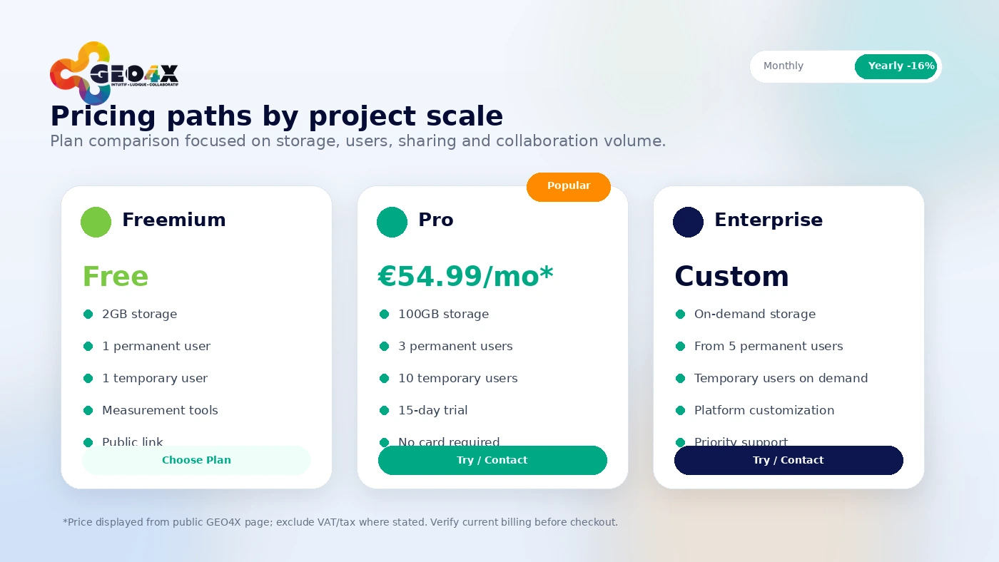
The current public pricing page gives buyers a useful first decision path: Freemium, Pro, or Enterprise.
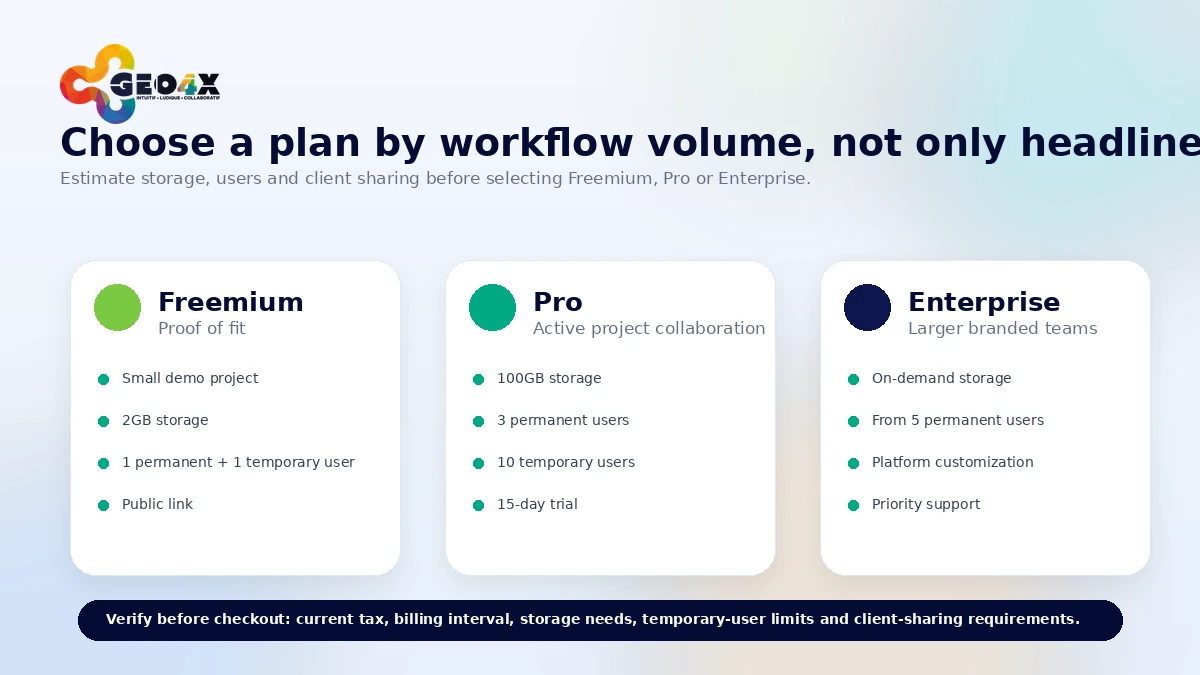
Freemium is the low-risk starting point. It is shown with 2GB storage, one permanent user, one temporary user, one administrator, permission-based sharing, measurement tools, public link support, and upload support for common geospatial outputs such as orthomosaics, digital elevation models, point clouds, and other files. The important limitation is not only storage. The pricing page also notes that free account data may be removed after 100 days of inactivity.
Pro is the realistic paid evaluation path. The public page shows Pro at €54.99 per month excluding tax, with 100GB storage, three permanent users, ten temporary users, and a 15-day trial with no credit card required. That is a sensible test path, but I would not judge it only by the monthly number. A geospatial platform can become expensive or limiting if storage, roles, dataset size, or client access do not match how projects actually run.
Enterprise is the route for larger or more customized deployments. It adds on-demand storage, more permanent users, temporary users on demand, platform customization, custom-built features, priority support with a dedicated account manager, and bank transfer. That is not a casual upgrade. It is for teams that already know GEO4X has become part of a business workflow.
My pricing take is simple: use Freemium or demos first, move to Pro only with a real project, and consider annual billing only after the platform proves repeated value. For professional buyers, also read the terms around renewal, cancellation, data retrieval, and responsibility for uploaded project data before paying.
Pricing check: If GEO4X fits your project workflow, verify live pricing, tax, trial timing, and the current buyer route before choosing Pro or annual billing.
Free plan, trial, coupon, and checkout notes
GEO4X is the kind of product where the free path matters more than a coupon path.
The public demos are useful because they let buyers see real project contexts before uploading their own sensitive or client-owned data. Demo categories include inspection, thermography, mapping, stockpile volume, facade inspection, industrial chimney inspection, survey and plans, LiDAR terrain, coastline, and earthworks examples. That is a much better first step than jumping straight to a subscription.
The Freemium plan is a better proof-of-fit path for smaller tests. Use it to answer basic workflow questions: can the viewer handle the kind of data you care about, can a non-technical stakeholder understand it, and do the measurement and sharing features reduce back-and-forth?
The Pro trial is where the real decision starts. A 15-day no-card trial is useful, but only if you bring a realistic project into it. Do not waste the trial exploring random demos if your actual work involves large point clouds, thermography, client permissions, or repeated stockpile measurements.
Coupon and affiliate routes should come after workflow fit. If an active offer or customer discount is available, it can improve the purchase. It should not be the reason you buy.
What I would check before buying GEO4X
If I were buying GEO4X for a real geospatial workflow, I would check seven things before paying:
- Dataset fit: Does GEO4X support the files you actually need to upload, view, measure, export, and share?
- Storage: Is Freemium’s 2GB enough for testing, and is Pro’s 100GB enough for your recurring projects?
- User roles: Do one permanent user, temporary users, visitors, and project managers match the way you work with clients and partners?
- Measurement needs: Are distance, area, volume, slope, profile, and related tools enough for your use case?
- Professional accuracy: Are your outputs informational, operational, contractual, engineering, or legal? The answer changes how cautious you should be.
- Cancellation and data retrieval: Can you cancel in time, and can you download your data within the post-termination window?
- Alternative fit: Would a production-heavy photogrammetry tool, drone operations platform, open-source workflow, or construction-focused measurement platform be better?
A simple test before paying
Before paying for GEO4X, I would run a small test like this:
- Open two or three public demos that resemble your actual work.
- Create or use a Freemium workspace if the demo experience looks relevant.
- Upload a non-sensitive project sample that includes the type of data you expect to repeat.
- Ask one non-technical stakeholder to open the project and complete a simple viewing or measurement task.
- Test permission levels with at least one internal user and one temporary or visitor-style user.
- Check whether the needed measurements, exports, and supporting documents are clear enough for client handoff.
- Compare the result with your current workflow: desktop exports, PDF reports, file-sharing links, or manual walkthroughs.
The test is not about whether GEO4X looks polished. It is about whether it removes enough friction to justify becoming part of your project delivery process.
Pros explained
The first major pro is focus. GEO4X is not trying to be a generic cloud workspace. It is built around geospatial data, hosted viewing, measurements, sharing, and project access. That narrowness is useful when the buyer’s real pain is geospatial collaboration.
The second pro is low-risk evaluation. Public demos, Freemium, and a Pro trial make it easier to test before paying. For a tool that may handle large files and client-facing work, that matters.
The third pro is client handoff. A browser-based project workspace can reduce the need to export endless screenshots, explain desktop software, or send huge file packages manually. This is where GEO4X can save time if the workflow repeats.
The fourth pro is professional access control. Permission roles, visitors, public projects, and white-label positioning are relevant when a buyer wants a controlled client experience rather than a messy folder link.
The fifth pro is data governance context. EU/GDPR positioning, terms around client data, and structured data retrieval language are not enough by themselves, but they are meaningful for professional teams handling project information.
Cons explained
The first con is that GEO4X may be too specialized for casual users. If you only need to store a few files or send a one-off project, the paid plan can be more workflow than you need.
The second con is that it is not the same decision as buying a full production photogrammetry suite. GEO4X can support hosted deliverables and processing services, but buyers who need deep control over photogrammetry pipelines should compare production-focused alternatives before choosing.
The third con is plan dependency. Storage, user counts, temporary access, data inactivity, export expectations, and project volume can change the value calculation quickly. The Pro price is only meaningful after the buyer maps it to real usage.
The fourth con is refund clarity. The terms include cancellation and consumer withdrawal language, but I would not read them as a broad, simple professional-buyer refund promise. Any started period may remain due, and buyers should verify the current terms before subscribing.
The fifth con is integration uncertainty. If you need API-driven workflows, automated syncing, custom connectors, or deep system integration, confirm that directly before building around GEO4X.
Green flags and red flags
Green flags:
- You repeatedly deliver geospatial data to clients or partners.
- Your stakeholders struggle with large files or specialist desktop tools.
- You need browser viewing, measurements, and controlled sharing in one place.
- Freemium or Pro trial testing confirms that your real dataset works well.
- Storage, user limits, and data retrieval rules match your project rhythm.
Red flags:
- You only need a basic file-sharing folder.
- Your main need is advanced photogrammetry production control.
- You need legally certified survey outputs without confirming scope.
- You cannot explain who needs view, measure, download, or admin rights.
- You are choosing the plan because of a discount before testing a real project.
GEO4X vs alternatives
GEO4X should be compared by workflow, not by a generic feature list. Some alternatives are more direct for production, some are better for drone operations, and some are adjacent rather than one-to-one replacements.
Pix4D vs GEO4X
Pix4D is usually the stronger comparison when photogrammetry production depth matters more than hosted project handoff. If your priority is processing, reconstruction, mapping outputs, and professional production workflows, Pix4D may be closer to the center of the job.
GEO4X may still make sense if the bottleneck is not processing but sharing, viewing, measuring, and client access after deliverables exist.
DroneDeploy vs GEO4X
DroneDeploy is a stronger comparison for broader drone operations, reality capture, field workflows, and enterprise site visibility. It may be more appropriate for companies that want a larger operational platform around drone data.
GEO4X may be more focused if your current need is a cloud geospatial viewer and collaboration layer for project deliverables.
WebODM vs GEO4X
WebODM is an adjacent route for buyers who prefer open-source or self-managed photogrammetry processing. It can be attractive for technical teams that want more control and less dependence on a hosted SaaS model.
GEO4X is more relevant when the buyer wants a managed browser workspace, client access, and hosted sharing rather than a self-managed processing stack.
Propeller Aero vs GEO4X
Propeller Aero is more aligned with construction, earthworks, survey-grade site tracking, and operational measurement workflows. It may be the stronger fit when jobsite productivity and construction measurement systems are the center of the purchase.
GEO4X may be a lighter and more general geospatial collaboration layer when the buyer needs to centralize and share project data across different inspection, mapping, and infrastructure contexts.
Trust, refund, and buyer-risk notes
GEO4X handles project data that may be commercially sensitive, client-owned, location-specific, or operationally important. That makes the trust section more important than it would be for a simple SaaS dashboard.
On data responsibility, buyers should read the terms carefully. The client remains responsible for the quality, lawfulness, completeness, and provenance of uploaded data, as well as drone and aviation compliance where relevant. That is reasonable, but it means GEO4X does not remove the buyer’s professional obligations.
On output expectations, the terms are also worth reading. Deliverables depend on the quality of client data, and the platform does not automatically provide legal metric accuracy or certified surveying/topographic documents unless that is expressly stated. If you work in high-liability contexts, get clarity before relying on outputs.
On privacy and security, GEO4X presents GDPR-aligned language, EU-oriented hosting context, security controls, and processor/controller roles. That is useful, but it is not a reason to skip your own internal review. If you upload client sites, infrastructure, inspection imagery, or sensitive location data, confirm whether the arrangement fits your contracts and data policies.
On cancellation, the terms state that subscriptions renew by billing period and cancellation is effective at the end of the current term. Data can be downloaded for a limited period after termination before deletion. That should influence how you offboard projects if you stop using the platform.
The buyer risk is not that GEO4X looks unserious. It is that a buyer may underestimate the operational questions: dataset size, file type, precision needs, client access, data retention, and professional responsibility.
Final verdict
GEO4X is a strong consideration if your team repeatedly works with drone, survey, inspection, construction, quarry, or infrastructure data and needs a browser-based way to view, measure, organize, and share geospatial projects.
I would consider GEO4X if you need clients, field teams, managers, or partners to access the same geospatial project without juggling heavy files and specialist tools. I would also consider it if Freemium or the Pro trial handles a real dataset well and the user-role model matches your handoff process.
I would skip GEO4X if you only need a simple download folder, if your main pain is advanced photogrammetry production, or if your work requires certified survey-grade outputs that have not been scoped clearly.
I would compare it with Pix4D if processing depth is the center of the decision, DroneDeploy if broader drone operations matter, WebODM if you prefer open-source control, and Propeller Aero if construction or earthworks measurement is the main workflow.
The safest next step is not to chase a discount first. Open the demos, test Freemium or the Pro trial with a real project sample, confirm storage and role limits, then decide whether GEO4X belongs in your recurring geospatial delivery workflow.